
DMap – A New Way to Map Density and Air Void Content in Asphalt Using AIR GPR
For Pavement Quality Control
Proven Results with Minnesota Department of Transportation (MnDOT)
Trunk Highway 22
Orbit DMap assessed 63.26 miles, an average density of 93.4% with reduced variability and fewer core samples needed.
Trunk Highway 15
Over 28.4 miles, DMap showed a 93.9% average density, saving costs by minimizing disincentives and improving quality.
Trunk Highway 35
DMap reporting showed enhanced density consistency in a 34.83 mile stretch with much faster collection and allowing reduced coring compared to traditional methods.
Watch the full research presentation on Minnesota DOT's research findings on dielectric mapping for pavements
Minnesota DOT is pioneering new techniques to QA new pavement construction using dielectric mapping to determine pavement density. Kontur's DMap allows you map the pavement dielectric values - in vehicle, at speed.
QC/QA for New Pavement Construction:
Minimize Risk, Maximize Longevity
Achieving optimal pavement density and air void content is critical to ensuring the structural integrity and long-term performance of new pavement. Accurate compaction directly reduces future maintenance costs by reducing the likelihood of long-term failures such as cracking, rutting, and premature wear – ultimately protecting your investment.
Instant Results, No Technical Bottlenecks
With Kontur DMap, you get automated, push-button dielectric evaluation of pavement density across the entire road area – delivering actionable insights within minutes.
Clear Data for Confident Decisions
Kontur DMap provides intuitive, easy-to-read visualizations that empower field teams and decision-makers alike, making it simple to use, even without specialized GPR expertise.
This means faster QA cycles, streamlined workflows, and better-informed decisions – keeping projects on time and on budget.
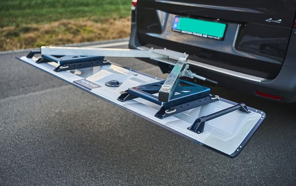
Kontur AIR
Kontur DMap is compatible with all Kontur AIR sensors. To enable Kontur DMap, your sensor must be configured accordingly and paired with an active Kontur Orbit service.
Trusted globally for applications like pavement inspections, airport and railroad evaluations, and even landmine detection,
AIR offers unparalleled safety by maintaining a secure distance from the ground – all at highway speeds
Kontur Orbit

© 2025 Kontur AS. All rights reserved.